June 16 CARD STREET FIRE UPDATE Evacuations map + 1500 acres burned

#CardStreetFire Evacuation Areas, June 16 2015, 12:30pm

From Kenai Peninsula Borough Office of Emergency Management:
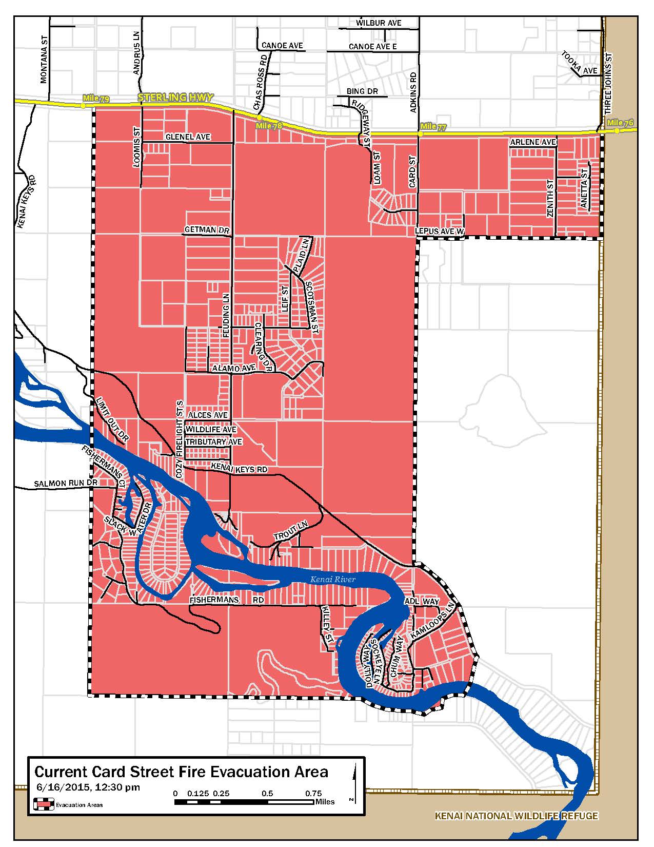
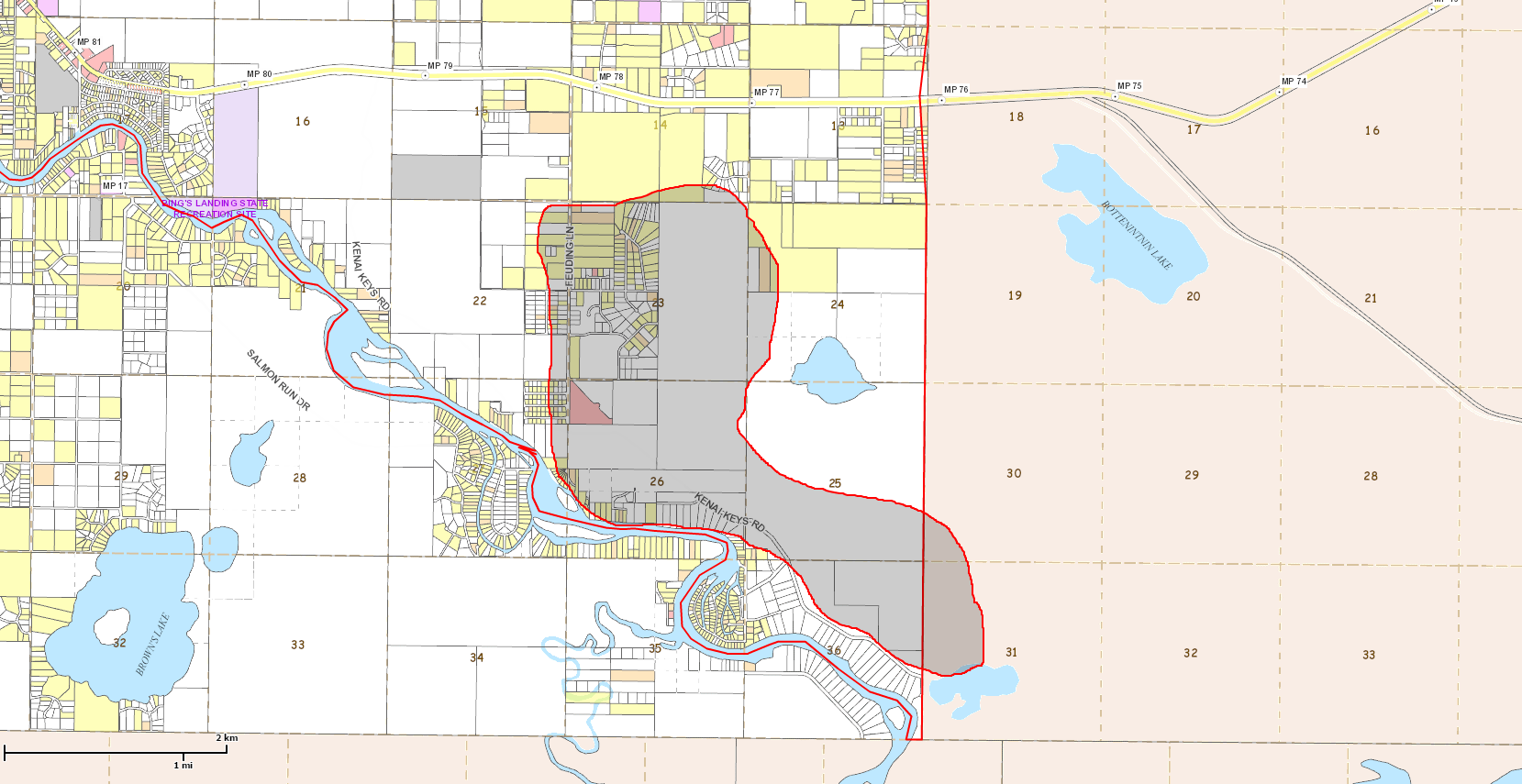
The map indicates the evacuation perimeter for affected Sterling and Funny River subdivisions. The map will be updated as information changes and is available at www.kpb.us and www.facebook.com/kenai.peninsula.borough

CURRENT EVACUATION AREA | June 16, 2015, 12:30 p.m.

  • Sterling area includes subdivisions from Card Street EAST to Kenai National Refuge boundary at Sterling Hwy. mile 76 and SOUTH to the Kenai River. This still includes Feuding Lane and Kenai Keyes.
  • Funny River area includes subdivisions off the end of Salmon Run Drive to the end of Fisherman’s Road and Dow Island residents.
  • Printable PDF: Evacuation Areas June 16, 2015, 12:30 p.m.

Please stay away from the evacuation areas and use caution when driving through smoke or passing fire apparatus. Do not attempt to return to evacuated areas. Updates will be provided to all local radio stations, Rapid Notify and KPB Facebook page when evacuations are lifted.

ONLINE LINKS

Approximate Fire Perimiter 1500 acres
Approximate #CardStreetFire Perimeter, 1500 acres, June 16, 2015, 12:00 p.m.

The Kenai Peninsula Borough provided this Alaska Forestry  update:

  • Approximately 1500 acres have burned. Three helicopters and three fixed wing aircraft and 50 crew are assigned to the fire. Air attack and retardant will resume this morning. Five hot shot crews are arriving late afternoon today and the Type 2 team is expected tomorrow.
  • Six structures are confirmed lost, and Forestry is currently conducting structural, damage assessments. The borough will work with the assessing department to confirm addresses and contact home owners directly just as soon as we receive the information.
  • Once the Type 2 team is operational, perimeter mapping will be provided. Until that time, the Alaska Interagency Incident Management Team has a mapping tool that tracks fire activity at http://afsmaps.blm.gov/imf_fire/imf.jsp?site=fire

The borough will continue to provide resources and support as requested.

###

Helpful Facebook links:


Funny River Fire update: 67,084 acres with 15 percent containment. Red Flag Warning in effect.

ALASKA INTERAGENCY INCIDENT MANAGEMENT5-23-14 - Funny River Fire Update
TYPE 2 TEAM
Rob Allen, INCIDENT COMMANDER
FIRE INFORMATION
PHONE: (907) 714-2484
INCIWEB: http://inciweb.nwcg.gov/incident/3878/
EMAIL: funnyriverfire@gmail.com

10:30am May 23, 2014

PDF: 5-23-14 – Funny River Fire Update

FUNNY RIVER FIRE UPDATE
67,084 acres with 15% containment. Red Flag Warning in effect.

The fire is 67,084 acres and is still contained within the Kenai National Wildlife Refuge. Good progress was made yesterday with 15% containment achieved with secure line on the north east flank of the fire. There are 374 personnel assigned to fire.

Over 400 people attended public meetings in Kasilof and Funny River last night with the meetings simulcast on a local radio station. Local residents expressed concerns about campfires being allowed in the area over the upcoming Memorial Day weekend with the very dry forest and red flag weather conditions. As of 4pm, May 22, 2014, the fire was 3.5 miles from the Kasilof River, 3 miles east of the Pollard Subdivision, and 3.5 miles from the Cardwell area and less than 2 miles from the Bear Creek Subdivision on Tustumena Lake. The fire perimeter reaches Funny River Road at mile 7.5 to the north and the shores of Tustumena Lake to the south. During last night’s operation, structural fire crews from around the state protected Funny River road. Smoke jumpers were dispatched to the water accessible only Bear Creek subdivision as the fire moved within 2 miles of the subdivision. Today, on the east flank, helicopters with water buckets are assisting crews to protect the Funny River community to the north. The presence of a vegetative fuel break along the northeast boundary of the Refuge has assisted fire crews in protecting the community of Funny River. To the south, an additional fire crew from Oregon is assisting the smokejumpers at Bear Creek subdivision in structure protection activities. On the west flank, crews are working to extend the containment line down to Cole Lake. Four water scooping aircraft (CL215s) are operating to protect the community of Kasilof. These aircraft are scooping water from Tustumena and Skilak Lakes.

An increase in fire activity is expected this afternoon with southwest winds 6 to 12 MPH gusting to 20 MPH. Vegetation remains extremely dry on the Kenai Peninsula. Residents and visitors are urged to use extreme caution with anything that could ignite a fire. Weekend visitors to the area and residents are reminded that fire crews, air and ground equipment are working in close proximity to the Sterling Highway and Funny River Road. Do not block roads to view the fire. Pull off only in safe designated pullouts.

Information about current smoke conditions is available from the Alaska Department of Environmental Conservation at http://dec.alaska.gov/air/am/smoke.htm

Kenai Peninsula Borough Office of Emergency Services has set up a call line to help homeowners with fire preparedness. Residents can call (907) 714-2495. Information is available at http://www.borough.kenai.ak.us/emergency-mgmt/fire

###

Funny River Fire Map 5-23-14