Alaska DNR- Division of Forestry (DOF) UPDATE 5:45 PM, Tuesday, June 16, 2015
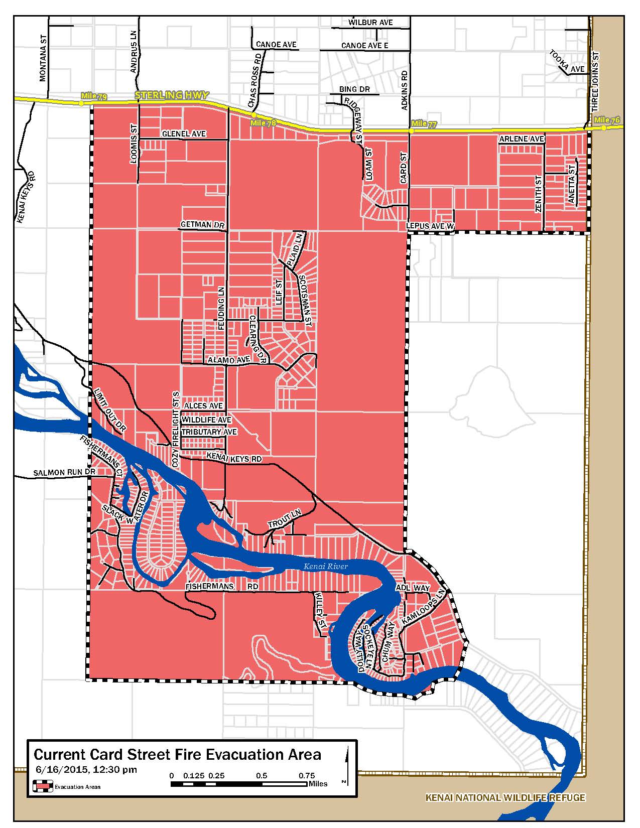
- The second evacuation of the day is underway in the Kenai Keys subdivision on the Kenai Peninsula due to the Card Street Fire, which is now estimated at 2,000 acres.
- The fire, which started yesterday, flared up on the southeast side and is less than a mile east of the subdivision. Firefighters are holding it out of the area but they want to get people out in the event wind associated with thunderstorm cells building to the east produces winds that could fan the flames.
- It’s the second time today and the third time in two days that an evacuation order has been issued for the area. An evacuation advisory was issued this morning because northerly winds were pushing the fire toward the subdivision along the Kenai River. Air tankers have been ordered to drop retardant on the encroaching fire and are enroute.
- Most of the fire activity on the fire today was on the east side of the fire and the fire has burned into the Kenai National Wildlife Refuge. The fire is burning about 1 1/2 miles from Skilak Loop Road, though it is not threatening anything on that side of the fire. The only structure there is an old U.S. Forest Service guard station that has been closed. Sprinklers have been set up around the guard station to protect it.
City of Soldotna Open Burn Ban
- Effective 5:00 pm, Tuesday, June 16, 2015, until further notice, per Central Emergency Services’ Fire Marshal Wes Perkins, there is no open burning allowed in the city of Soldotna limits, with the exception of covered barbeques only.
- The ban will be enforced by Soldotna Police Department.
Kenai Peninsula Borough UPDATE: 4:oo pm, Tuesday June 16, 2015
- Ten structures have been damaged in the Card Street Fire. The borough is confirming addresses and will be contacting residents as appropriate. As of 06/16/2015, the preliminary damage report confirms that three structures are homes.
- The call center cannot provide personal information regarding any damages to property or structures.
- Updates are regularly posted on www.facebook.com/kenai.peninsula.borough
- Register your mobile phone to receive emergency notifications through “Rapid Notify.” Visit www.kpb.us
- OEM call center information, please call 907-714-2495
Kenai National Wildlife Refuge UPDATE: 3:30 pm, Tuesday, June 16, 2015
Skilak Lake Road at Sterling Hwy is CLOSED
- Fire response activity is moving EAST toward the Refuge.
- ROAD CLOSURE: The WEST entrance of Skilak Lake Road at the Sterling Hwy will be closed to lower Skilak campground. The boat ramp at the campground will still be accessible. The closure will be until further notice due to fire activity.
Homer Electric Association | Hazard Tree Mitigation update
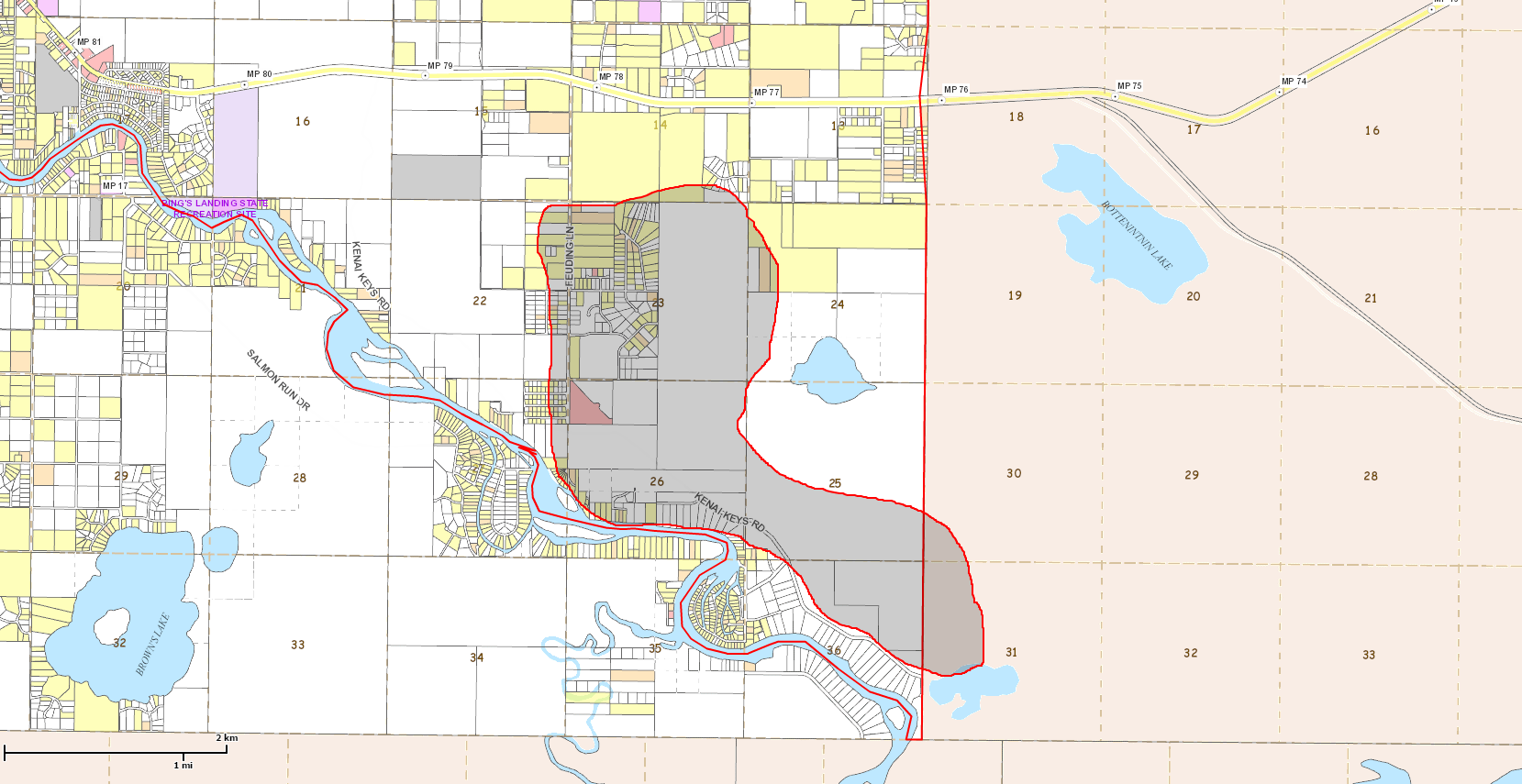
- In an effort to reduce further damage to HEA facilities and tree related power outages associated with the Card Street Fire in Sterling, HEA will be conducting hazard tree mitigation near overhead electric lines in the vicinity of Feuding Lane and Kenai Keys Rd. as soon as this afternoon, 6/16/2015.
- It is unknown at this time where the exact location of the current threats exist as line patrols are ongoing, but it has been determined that this work will occur along portions of the overhead lines within State maintained rights of way, across State owned lands within the Stephenkie Alaska Subdivision South of Kenai Keys Rd. as well as Kenai Borough lands South of Kenai Keys Rd., including KPB rights of way.
- Mitigation efforts will include the removal of burned or live vegetation that is currently deemed a “hazard tree” that could damage HEA facilities should it come within 5 ft. of contacting conductors if it were to fall toward the line. A combination of hand cutting using chainsaw and a dozer will be used to conduct this work.
- If you have questions please contact either Cody Neuendorf, Land Management Officer at 907-335-6209 (Office) or 907.398.6170 (mobile); or Jon Cress, HEA’s Director of Operations at 907-398-4942 (Mobile) or 907-283-2337 (Office)
Helpful Online Links:
- Alaska DNR- Division of Forestry (DOF)
- Alaska Interagency Incident Management Team
- Central Emergency Services
- Homer Electric Association, Inc
- Kenai Peninsula Borough
- Kenai Peninsula Borough School District
- Alaska Interagency Incident Management Team fire mapping tool to track fire activity
- Register your cell phone (KPB residents) to receive emergency notifications with Rapid Notify
- Wildfire evacuation preparation information: http://www.ready.gov/wildfires
- Fire updates: akfireinfo.com or facebook.com/AK.Forestry
###