 |
 Click Map to Enlarge (pdf) |
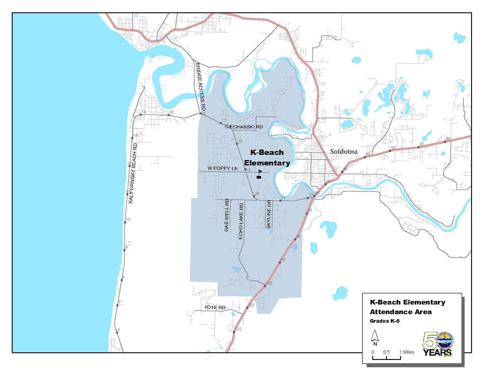
Kalifornsky Beach Elementary (K-6)
Along the Sterling Highway from the Soldotna Bridge at Mile 96 to Echo Lake Road at Mile 100, including Arc Loop, Echo Lake Road, Gaswell Road, and Wendy Lane. Along Kalifornsky Beach Road from Soldotna at Mile 22 to Bridge Access Road. Includes Skyline Drive, Poppy Lane, Murwood Avenue, and Ciechanski Road. |
 |
 Click Map to Enlarge (pdf) |
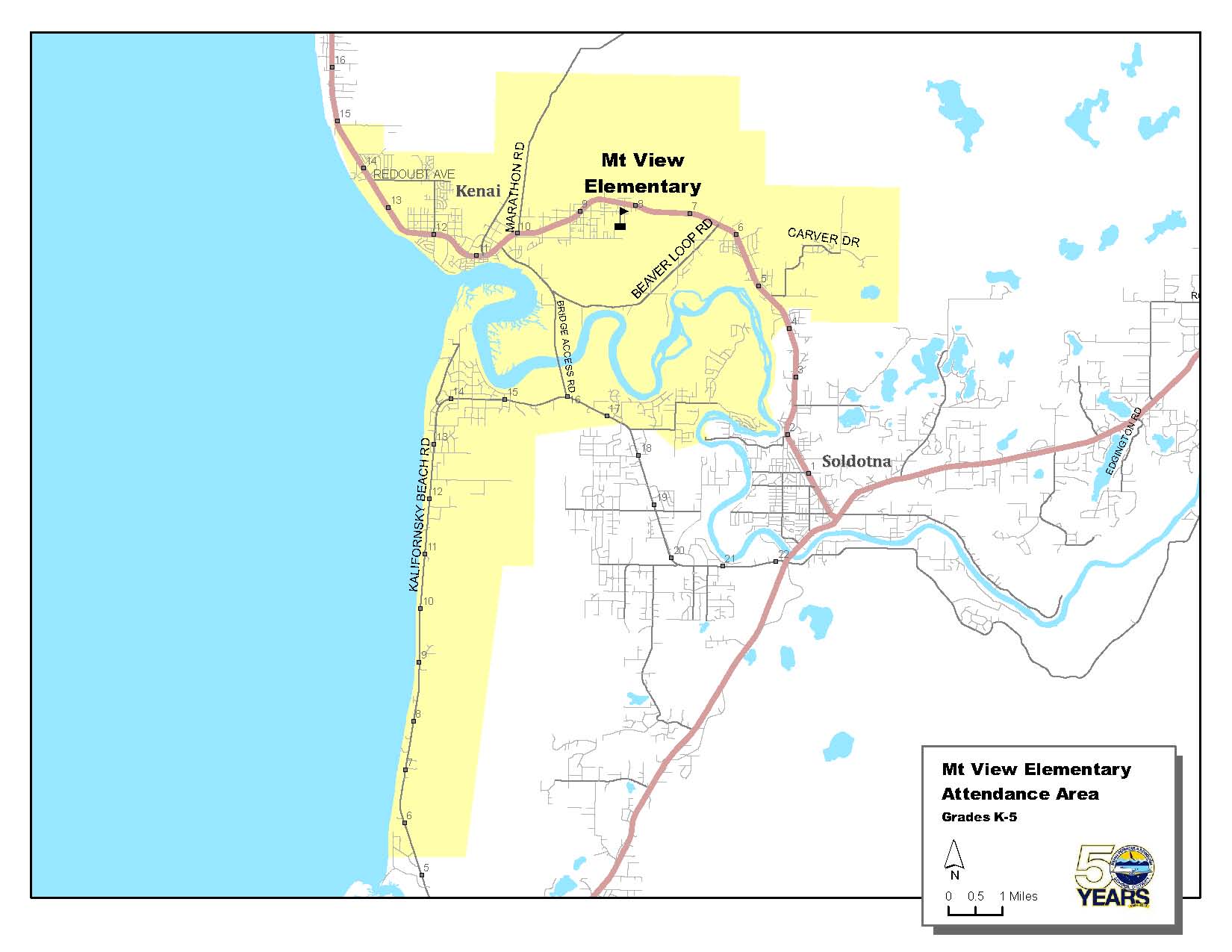
Mt. View Elementary (K-5)
The Spur Highway from approximately Mile 15 just past the Kenai City limits on the north (Borgen Avenue) to Mile 4.3 at Silver Salmon Circle on the east, including Strawberry Road, but not including Highlands Trailer Park Subdivision. The boundary on the south is approximately Mile 5.7 (Silvertip Net and Gear) Kalifornsky Beach Road. Includes the areas of VIP Estates, Cannery Road, and Robinson's store to Bridge Access Road. |
 |
 Click Map to Enlarge (pdf) |
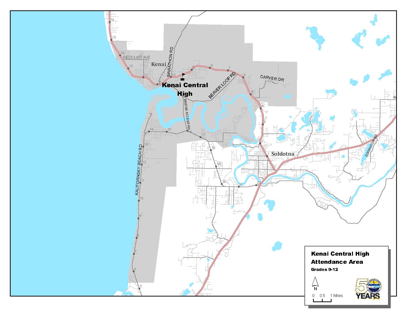
Kenai Central High School (9-12)
The Spur Highway from approximately Mile 15 just past the Kenai City limits to the Spur Highway at Silver Salmon Drive. Includes Strawberry Road, Carver Subdivision, and Silver Salmon Drive. Also includes the Old Town Subdivision, the area behind Kenai Elementary (Willow, Bluff, and Main Streets), and Kalifornsky Beach Road from and including Ciechanski Road to approximately Mile 5.7 (Silvertip Net and Gear) Kalifornsky Beach Road. Includes the areas of VIP Estates, Cannery Road, and Robinson's store. |
 |
 Click Map to Enlarge (pdf) |
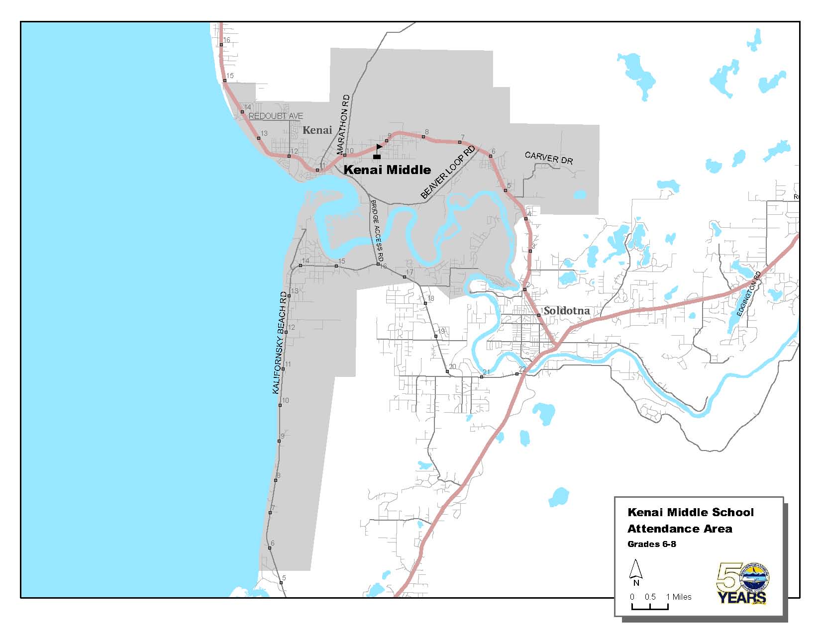
Kenai Middle (6-8)
The Spur Highway from approximately Mile 15 just past the Kenai City limits to the Spur Highway at Silver Salmon Drive. Includes Strawberry Road, Carver Subdivision, and Silver Salmon Drive. Also includes the Old Town Subdivision, the area behind Kenai Elementary (Willow, Bluff, and Main Streets), and Kalifornsky Beach Road from and including Ciechanski Road to approximately Mile 5.7 (Silvertip Net and Gear) Kalifornsky Beach Road. Includes the areas of VIP Estates, Cannery Road, and Robinson's store. |
 |
 Click Map to Enlarge (pdf) |
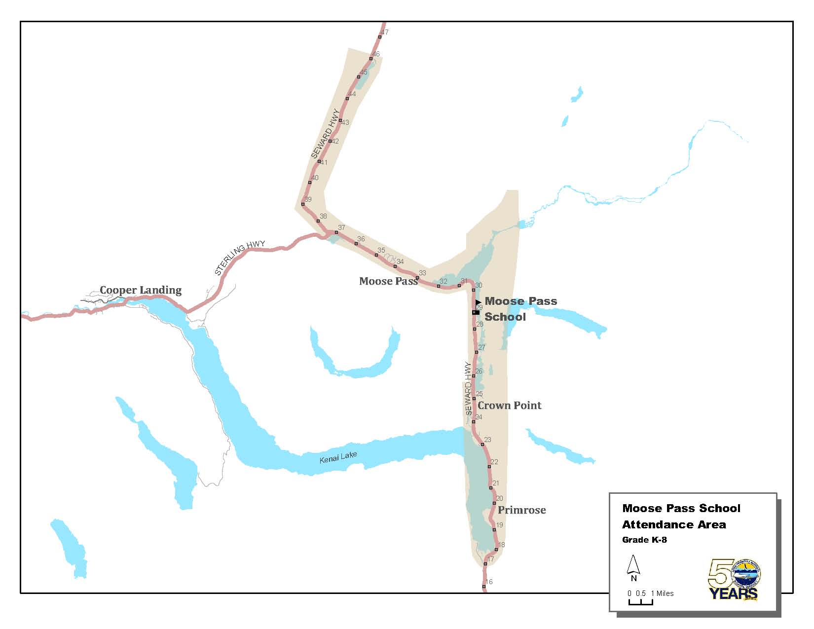
Moose Pass School (K-8)
From Summit Lake Lodge at approximately Mile 46 of the Seward Highway to Mile 17 at Primrose Lane. Moose Pass attendance area includes Primrose Lane. |
 |
 Click Map to Enlarge (pdf) |
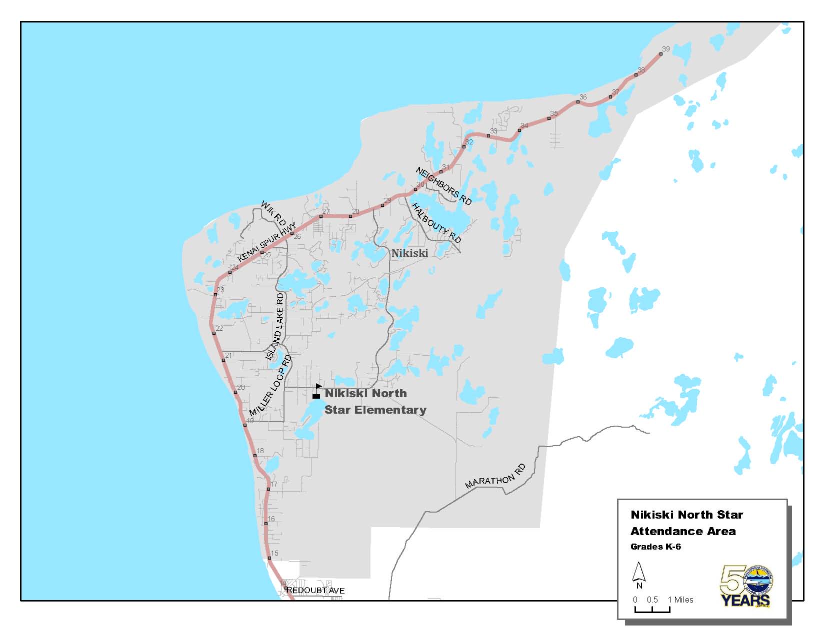
Nikiski North Star Elementary (K-5)
The area north of the Kenai City limits at approximately Mile 15 of the Kenai Spur Highway. |
 |
 Click Map to Enlarge (pdf) |
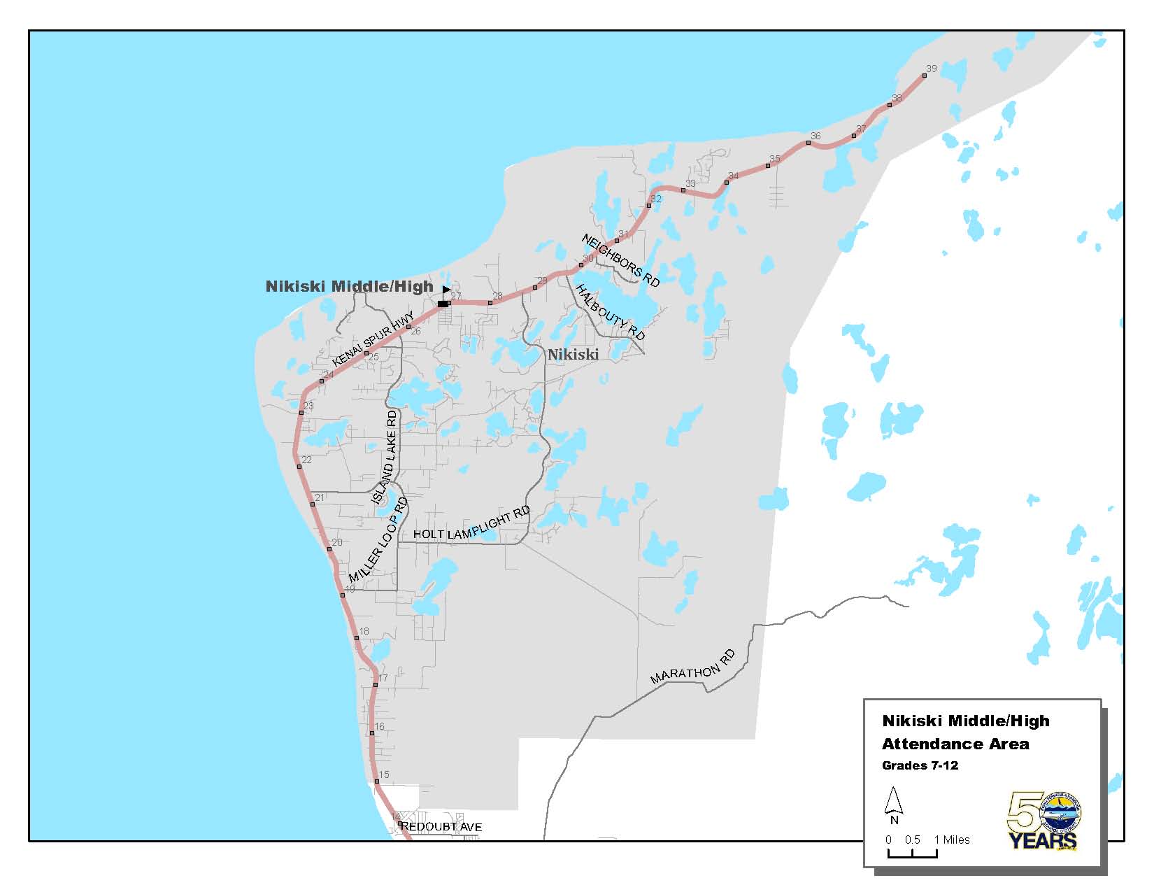
Nikiski Middle/High (7-12)
The area north of the Kenai City limits at approximately Mile 15 of the Kenai Spur Highway. |
 |
 Click Map to Enlarge (pdf) |
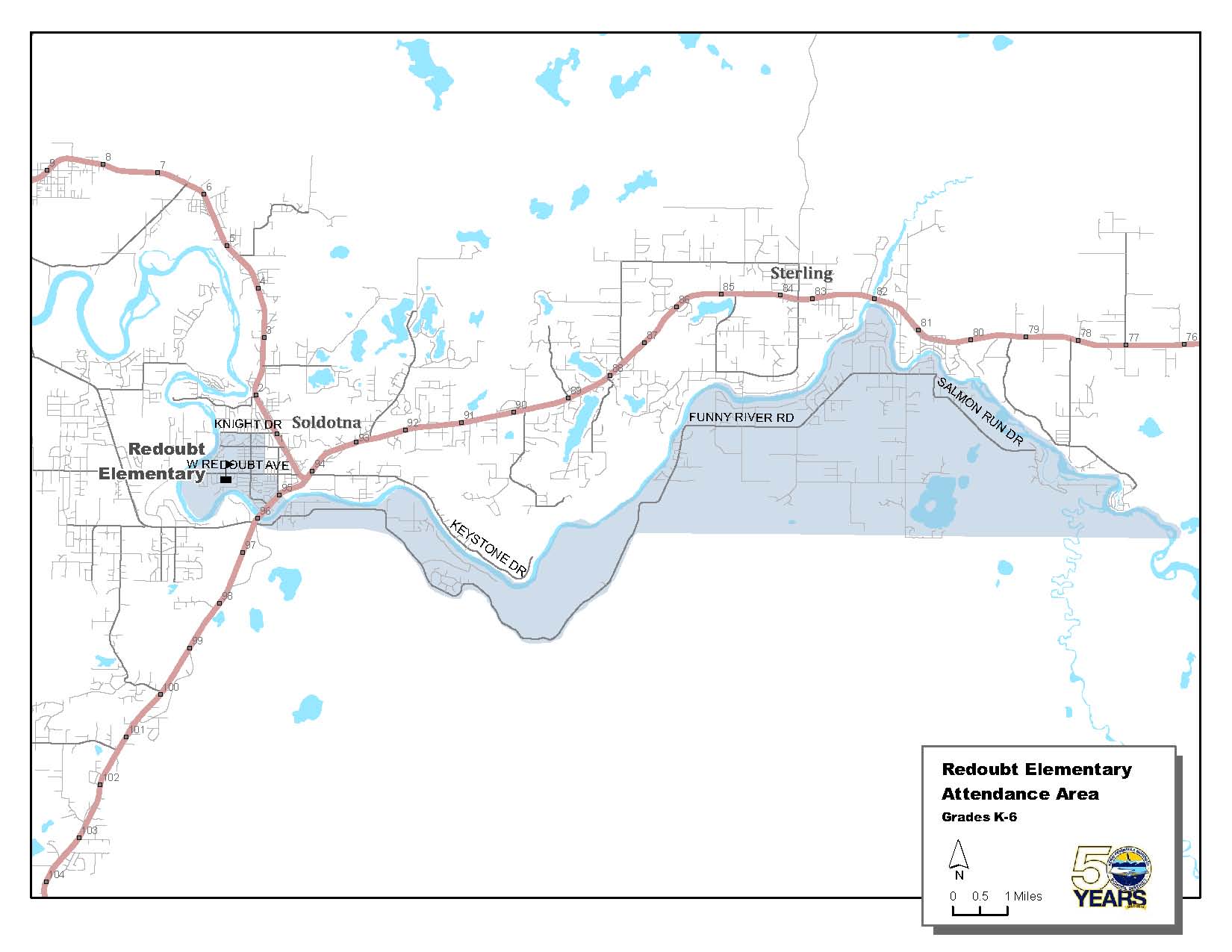
Redoubt Elementary (K-6)
All of Funny River Road and from the Soldotna bridge into town. In the city of Soldotna, all areas west of the line starting at the corner of the Sterling Highway and Binkley Street, north to Redoubt Avenue, west on Redoubt Avenue to Fireweed Avenue (road easement), north on Fireweed Avenue to Knight Drive, east on Knight Drive to the Spur Highway and west on Knight Drive to the Kenai River. |
 |
 Click Map to Enlarge (pdf) |
Seward Elementary (K-6)
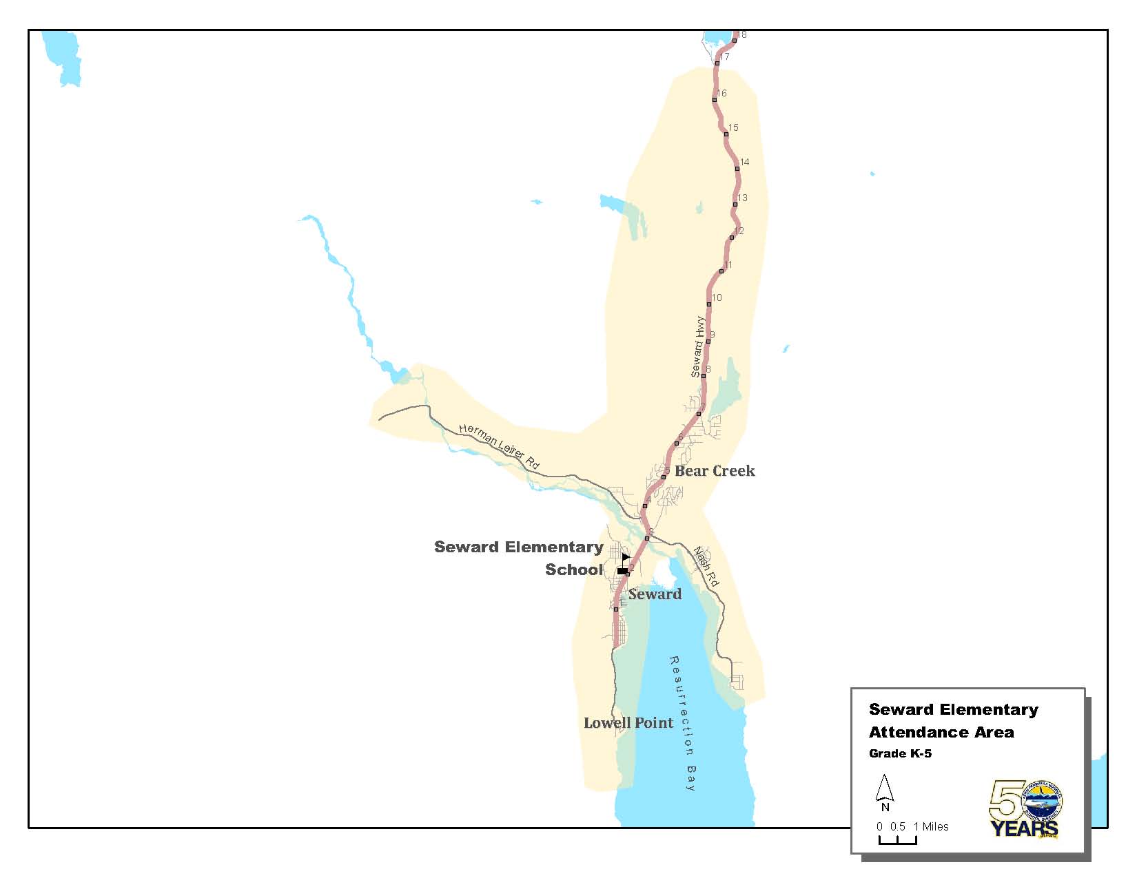
From Mile 17 of the Seward Highway, but not including Primrose Lane, to and including the city of Seward. Seward Elementary attendance area includes Exit Glacier Road, Nash Road, and Lowell Point. |
 |
 Click Map to Enlarge (pdf) |
Seward Middle (7-8)
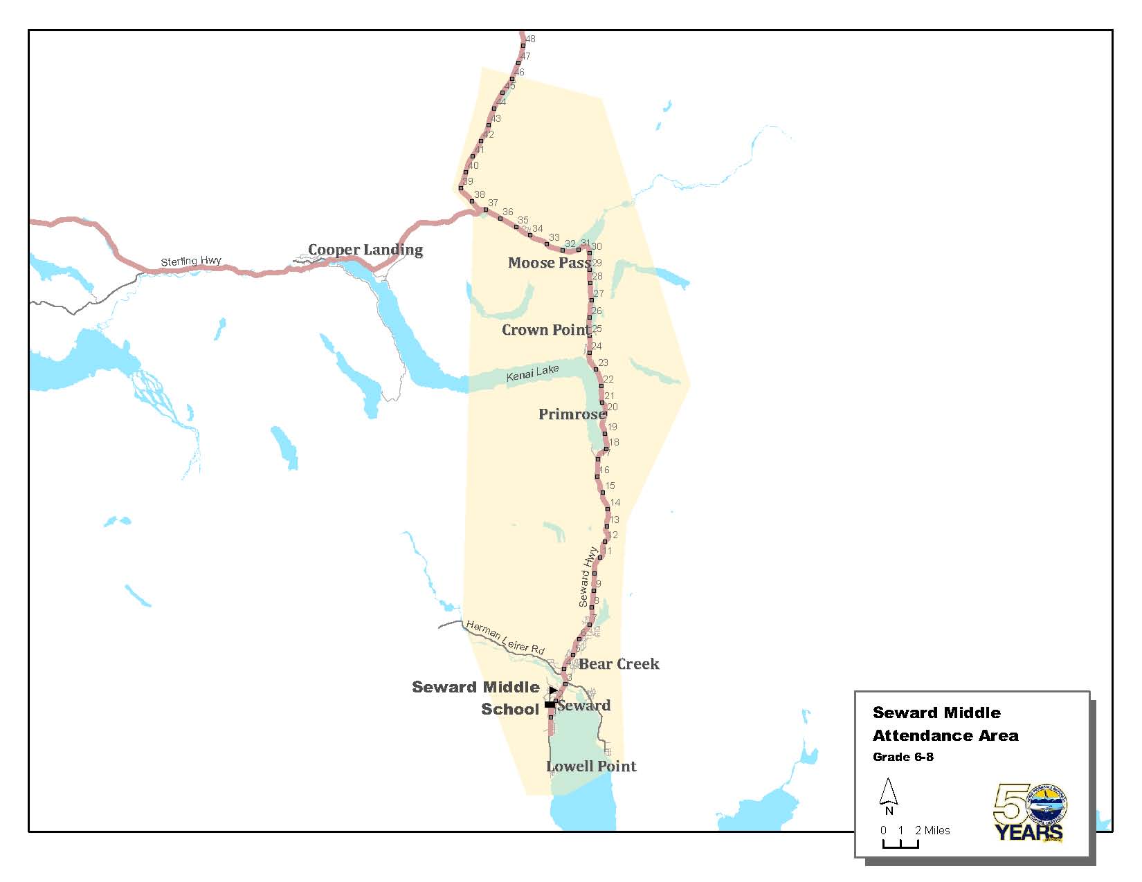
From Summit Lake Lodge at approximately Mile 46 of the Seward Highway to and including the city of Seward. Seward Middle and Seward High attendance areas include Exit Glacier Road, Nash Road, and Lowell Point. |
 |
 Click Map to Enlarge (pdf) |
Seward High (9-12)
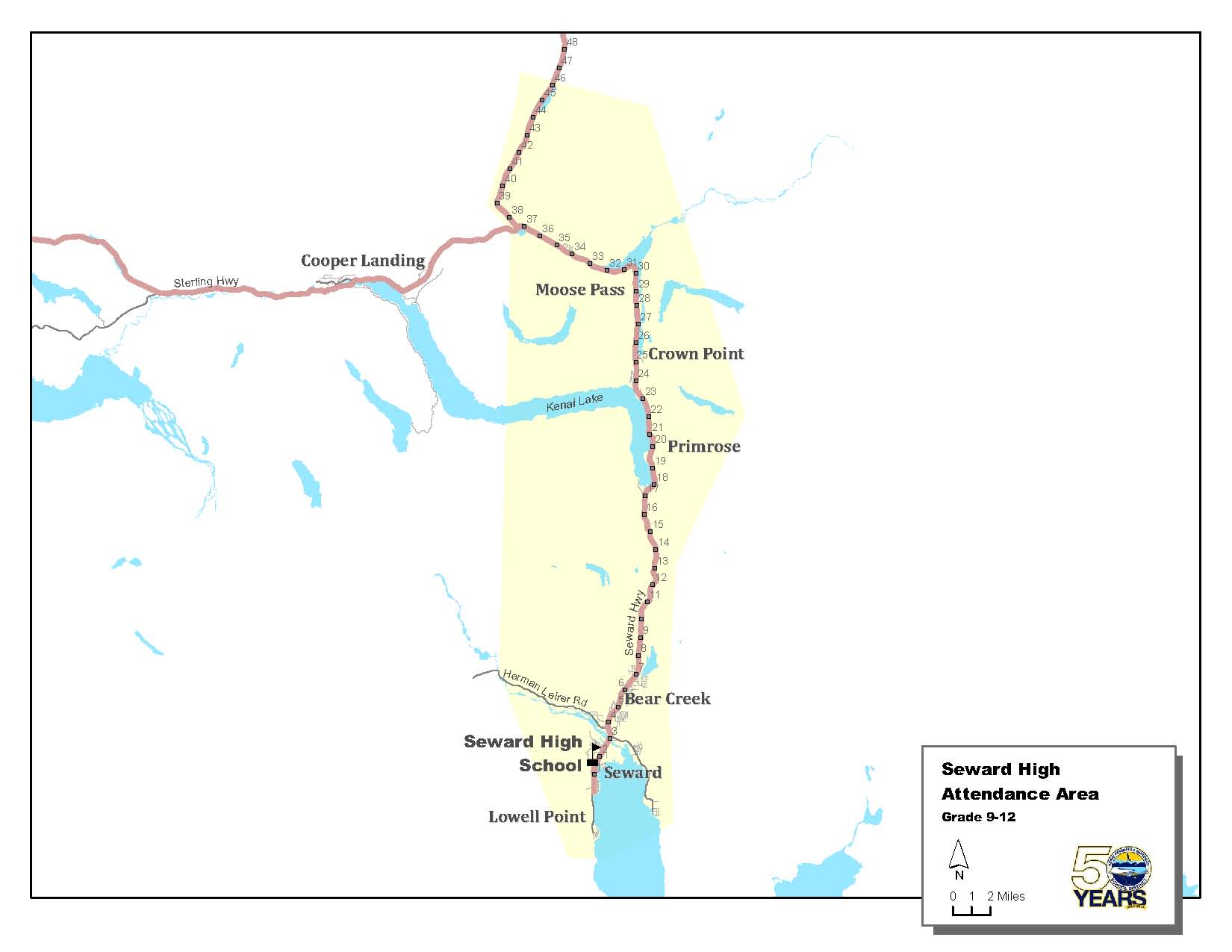
From Summit Lake Lodge at approximately Mile 46 of the Seward Highway to and including the city of Seward. Seward Middle and Seward High attendance areas include Exit Glacier Road, Nash Road, and Lowell Point. |
 |
 Click Map to Enlarge (pdf) |
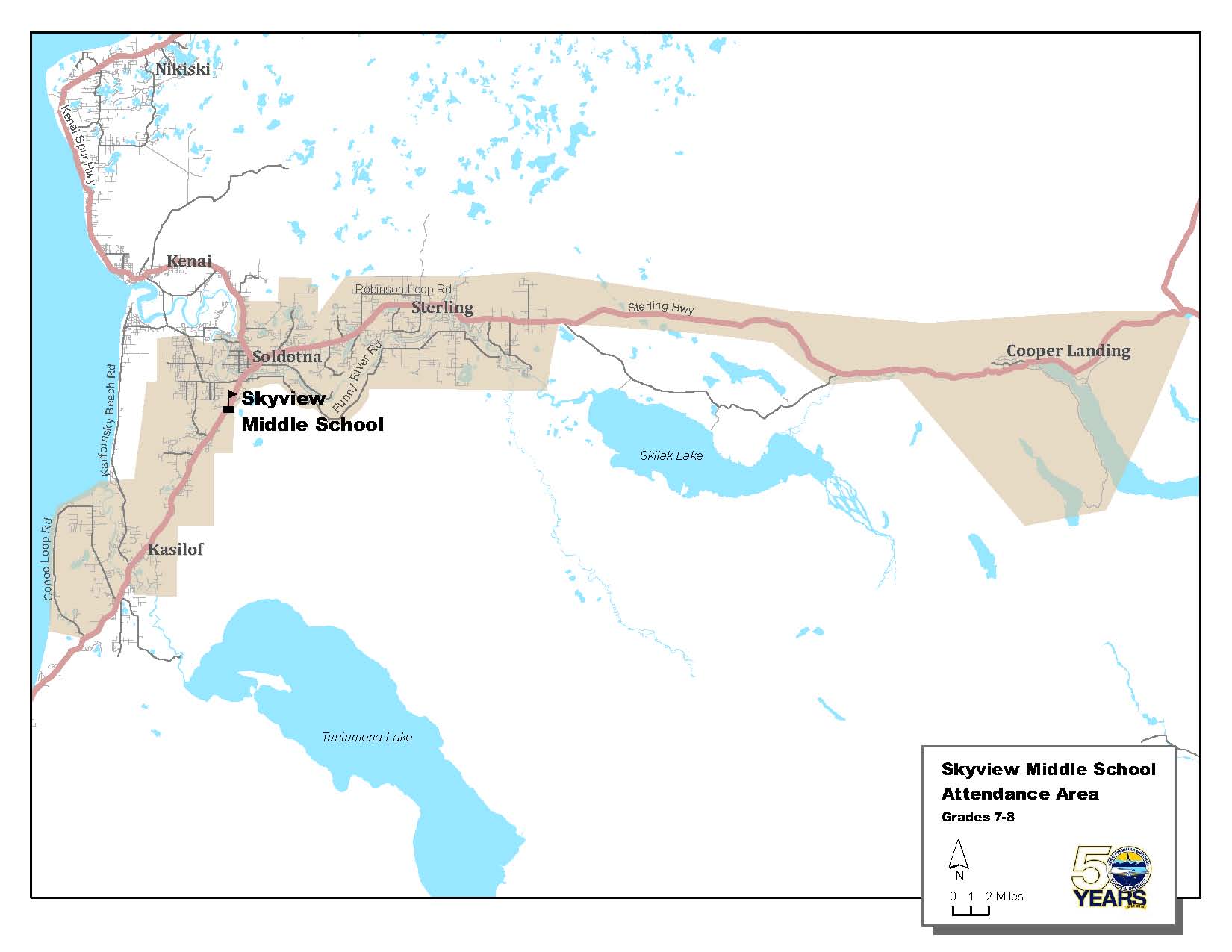
Soldotna Elementary (K-6)
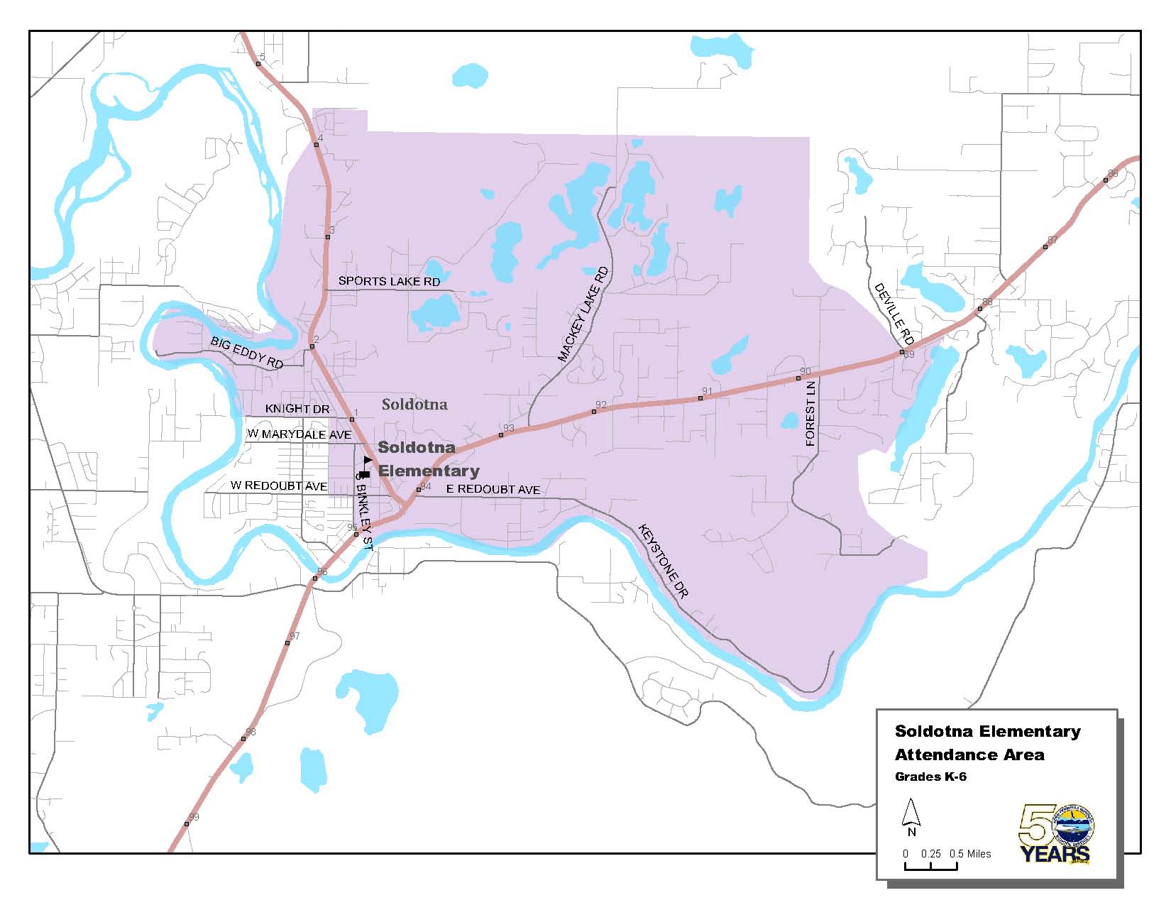
In the city of Soldotna, all areas east of the line starting at the corner of the Sterling Highway and Binkley Street, north to Redoubt Avenue, west on Redoubt Avenue to Fireweed Avenue (road easement), north on Fireweed Avenue to Knight Drive, east on Knight Drive to the Spur Highway, west on Knight Drive (includes the north side of Knight Drive) and north on the Kenai Spur Highway, to and including Highlands Trailer Park Subdivision. Includes Sport Lake Road, Big Eddy Road, and Irons Avenue. Encompasses east of Soldotna to approximately Mile 88.3 at the east end of Longmere Loop. |
 |
 Click Map to Enlarge (pdf) |
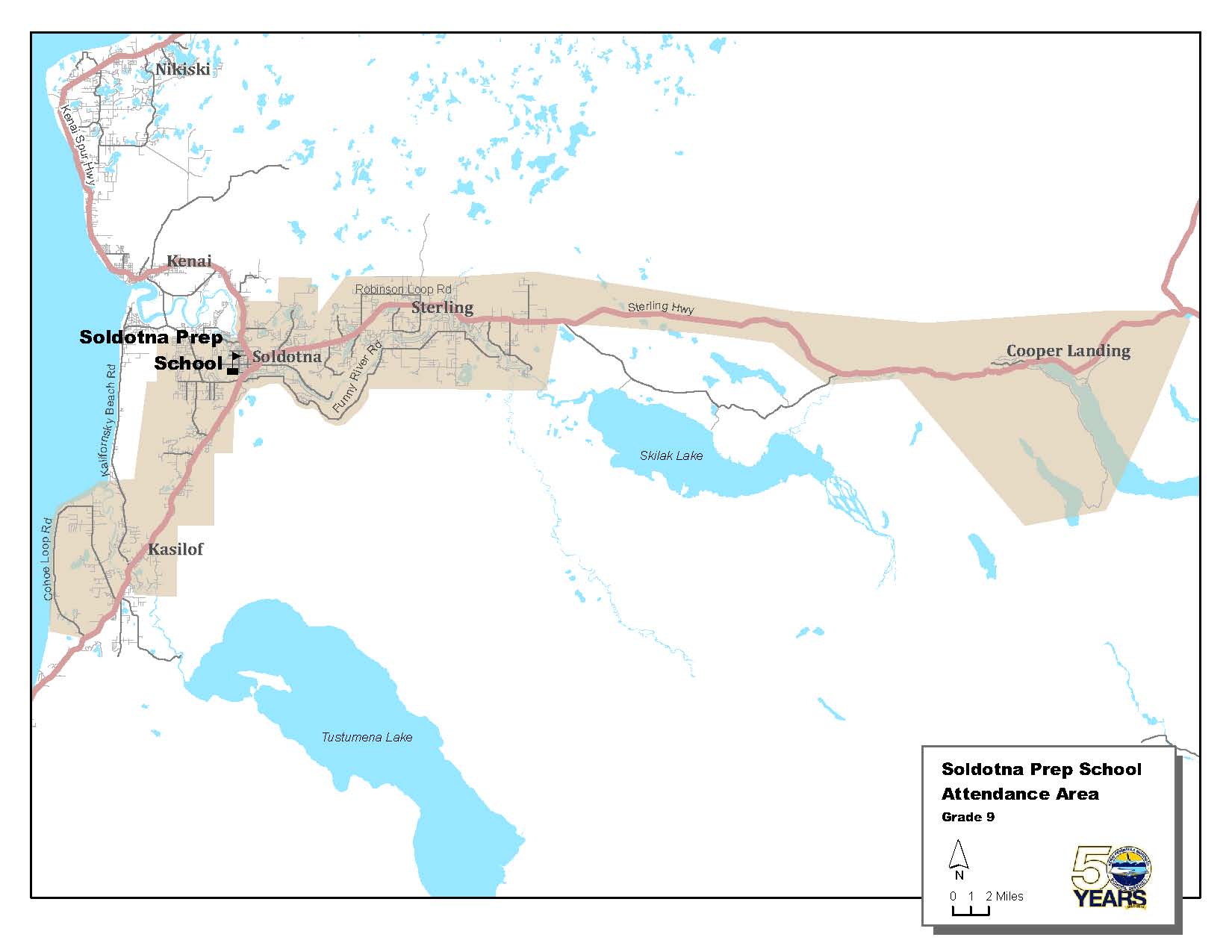
Skyview Middle (7-8)
On the Sterling Highway from Cooper Landing on the east at Mile 75.7 to Tustumena Elementary at approximately Mile 110 on the south. Also includes Coho Loop and from approximately Mile 5.7 (Silvertip Net and Gear) Kalifornsky Beach Road to Mile 0 in Kasilof. From Highlands Trailer Park Subdivision on the north at Mile 4.2 of the Spur Highway. From the Soldotna side of Ciechanski Road on Kalifornsky Beach Road to the Soldotna end at Mile 22. Includes all of Funny River Road. Includes Robinson Loop, Scout Lake Loop, Forest Lane, Mackey Lake Road, Denise Lake Road, East Pollard Loop, Echo Lake Road, Gaswell Road and Wendy Lane, Poppy Lane, Murwood Drive, Skyline Drive, Slikok Subdivision, Knight Drive, Irons Avenue, Cheechako News Drive, Sport Lake Road, and Highlands Trailer Park Subdivision. |
 |
 Click Map to Enlarge (pdf) |
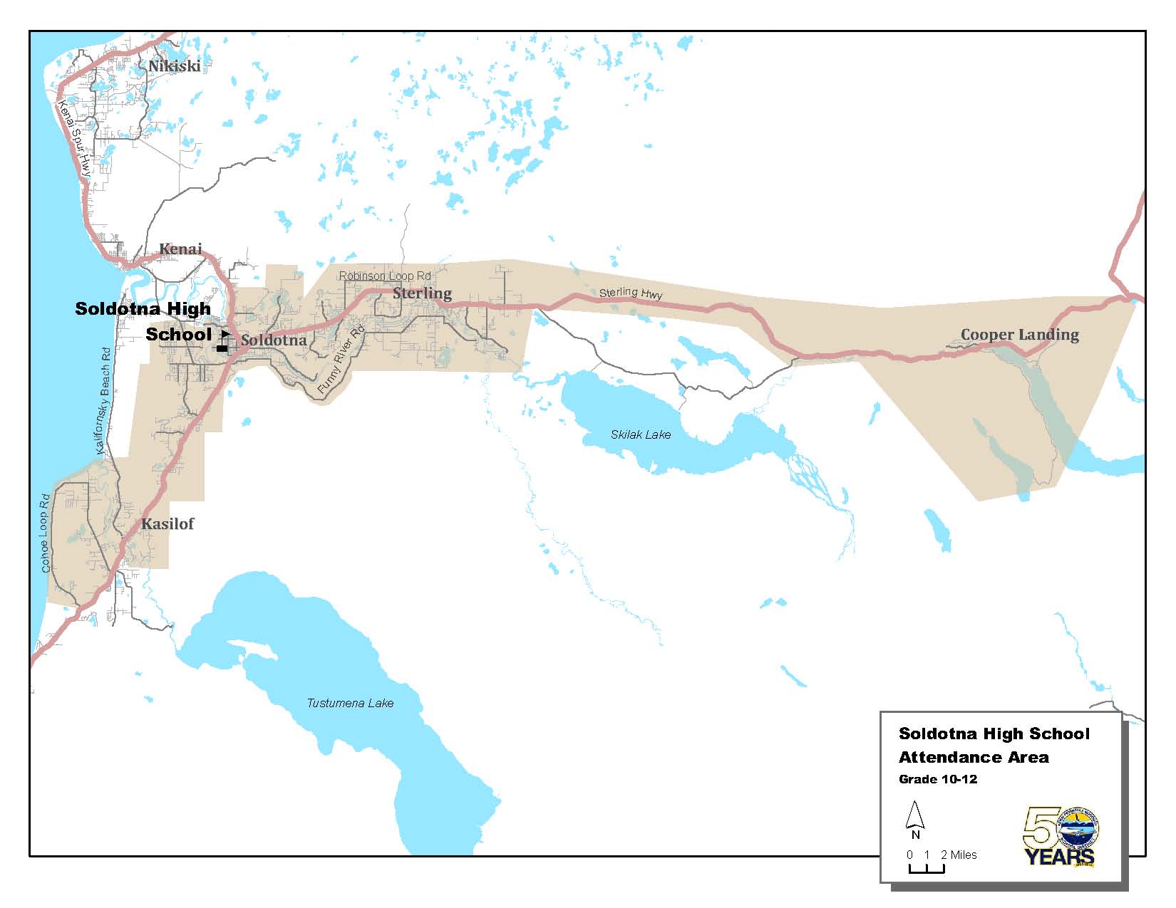
Soldotna Prep (9)
On the Sterling Highway from Cooper Landing on the east at Mile 75.7 to Tustumena Elementary at approximately Mile 110 on the south. Also includes Coho Loop and from approximately Mile 5.7 (Silvertip Net and Gear) Kalifornsky Beach Road to Mile 0 in Kasilof. From Highlands Trailer Park Subdivision on the north at Mile 4.2 of the Spur Highway. From the Soldotna side of Ciechanski Road on Kalifornsky Beach Road to the Soldotna end at Mile 22. Includes all of Funny River Road. Includes Robinson Loop, Scout Lake Loop, Forest Lane, Mackey Lake Road, Denise Lake Road, East Pollard Loop, Echo Lake Road, Gaswell Road and Wendy Lane, Poppy Lane, Murwood Drive, Skyline Drive, Slikok Subdivision, Knight Drive, Irons Avenue, Cheechako News Drive, Sport Lake Road, and Highlands Trailer Park Subdivision. |
 |
 Click Map to Enlarge (pdf) |
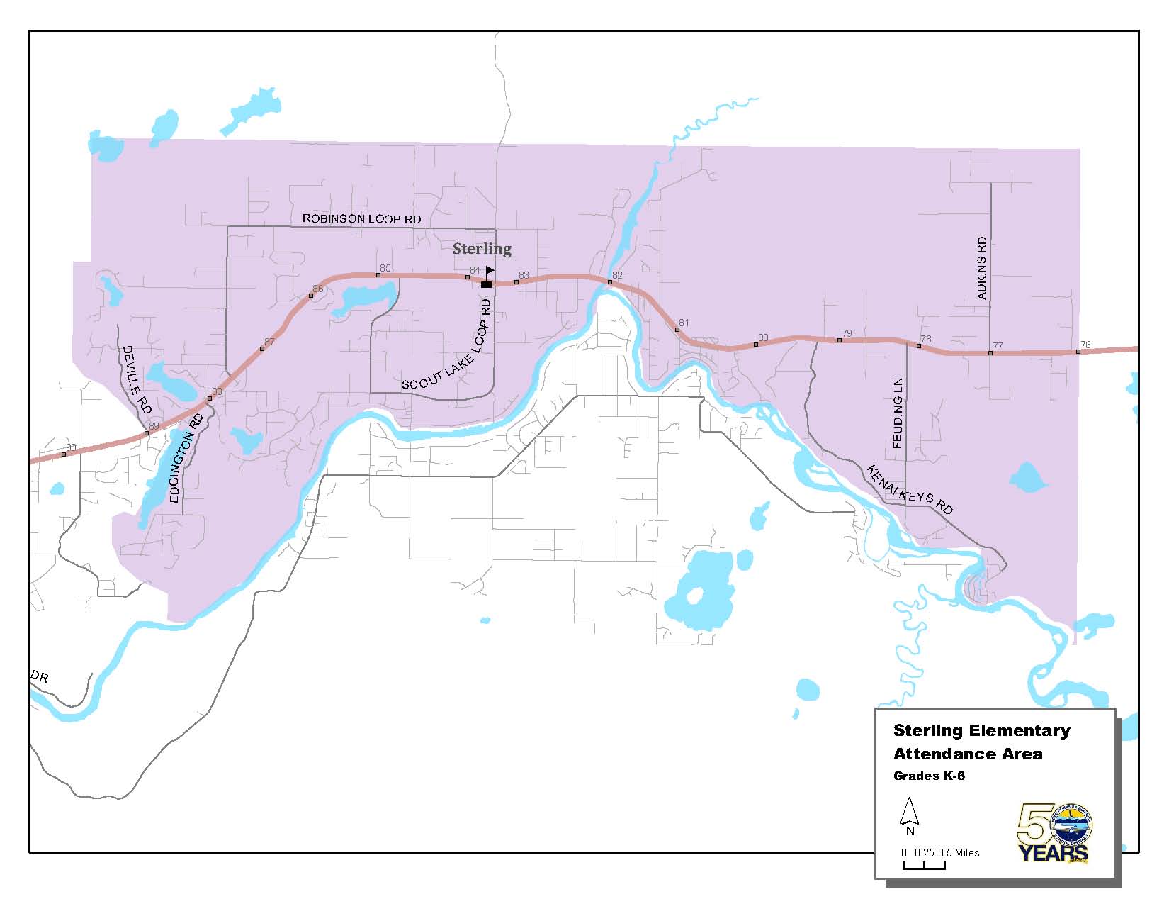
Soldotna High (10-12)
On the Sterling Highway from Cooper Landing on the east at Mile 75.7 to Tustumena Elementary at approximately Mile 110 on the south. Also includes Coho Loop and from approximately Mile 5.7 (Silvertip Net and Gear) Kalifornsky Beach Road to Mile 0 in Kasilof. From Highlands Trailer Park Subdivision on the north at Mile 4.2 of the Spur Highway. From the Soldotna side of Ciechanski Road on Kalifornsky Beach Road to the Soldotna end at Mile 22. Includes all of Funny River Road. Includes Robinson Loop, Scout Lake Loop, Forest Lane, Mackey Lake Road, Denise Lake Road, East Pollard Loop, Echo Lake Road, Gaswell Road and Wendy Lane, Poppy Lane, Murwood Drive, Skyline Drive, Slikok Subdivision, Knight Drive, Irons Avenue, Cheechako News Drive, Sport Lake Road, and Highlands Trailer Park Subdivision. |
 |
 Click Map to Enlarge (pdf) |
Sterling Elementary (K-6)
From Site 19 at Mile 75.7 Sterling Highway, west to the east end of Longmere Loop at approximately Mile 88.3. Includes Robinson Loop, Scout Lake Loop, and Lou Morgan Road. |
 |
 Click Map to Enlarge (pdf) |
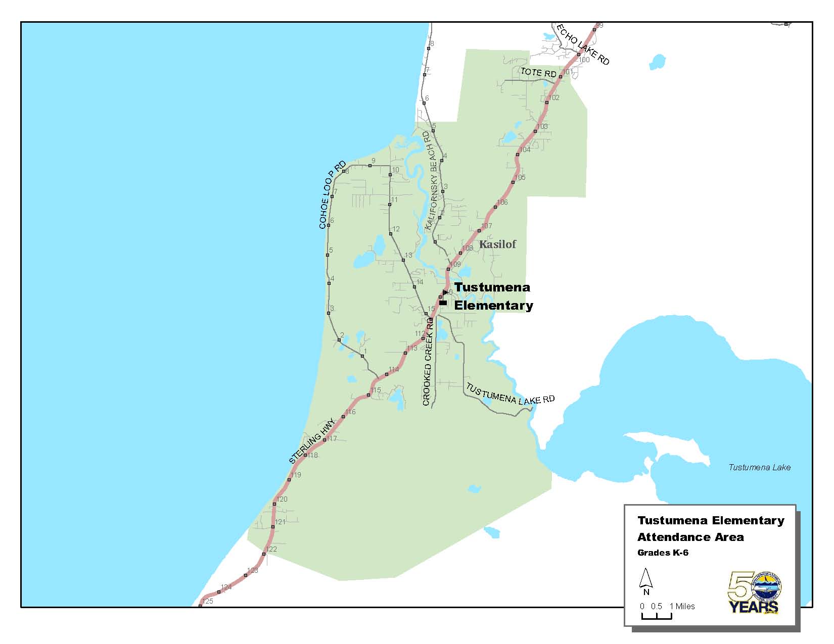
Tustumena Elementary (K-6)
From approximately Mile 100 Sterling Highway at Echo Lake Road south to approximately Mile 121.5 at Burger Drive/Falls Creek. Along Kalifornsky Beach Road from Mile 0 in Kasilof to approximately Mile 5.7 (Silvertip Net and Gear). Includes Tote Road, Reflection Lake Road, Pollard Loop, Coho Loop, and Tustumena Lake Road. |
 |
 Click Map to Enlarge (pdf) |
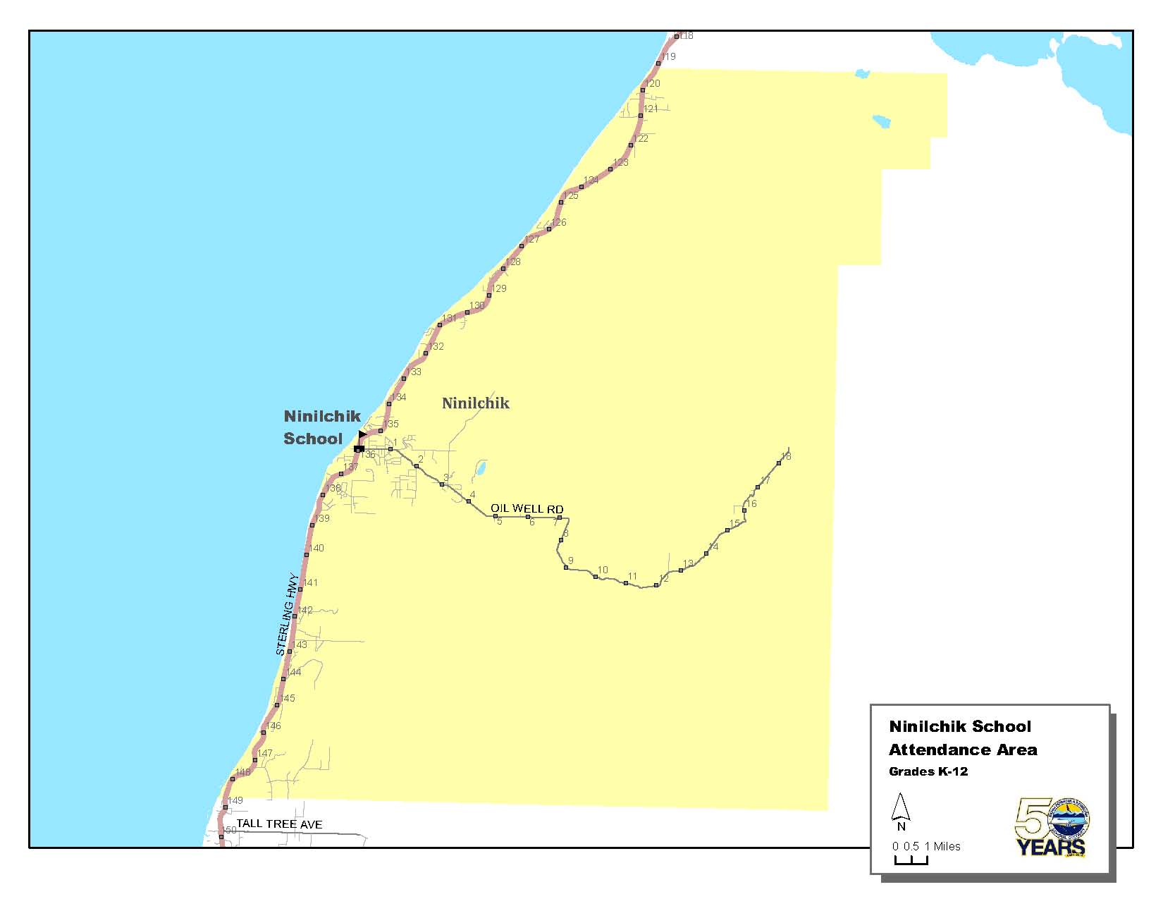
Ninilchik School (K-12)
For Grades K-6, as far south on the Sterling Highway as Stariski Tower at approximately Mile 147.2. and as far north on the Sterling Highway as Falls Creek turnaround at approximately Mile 121.5.
For Grades 9-12, as far south on the Sterling Highway as the North Fork Road. For Grades 7-12, as far north on the Sterling Highway as Tustumena School at approximately Mile 111. Includes Johnson Lake, Crooked Creek, and Youngstown. Ninilchik attendance area does not include Coho Loop, which is in the Skyview High School attendance area. |
 |
 Click Map to Enlarge (pdf) |
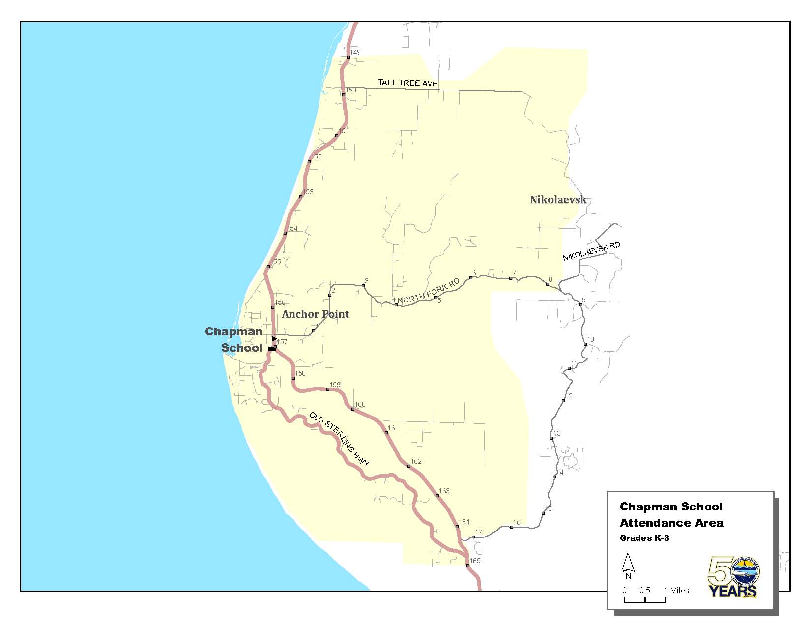
Chapman School (K-8)
From Starisky Tower at approximately Mile 147.2 on the north to Mile 8, including the Old Sterling Highway where the old and new Sterling Highways meet at approximately Mile 165. From the north end of the North Fork Road to the Nikolaevsk turnoff.
The exception to this boundary are the students living from the Nikolaevsk turnoff to the Hillside area 6 miles up the North Fork Road. These students have the option of attending Nikolaevsk School or Chapman School.
Grade 7 and 8 students living at the south end of the North Fork Road have the choice of being bused to either Chapman School or Homer Middle. |
 |
 Click Map to Enlarge (pdf) |
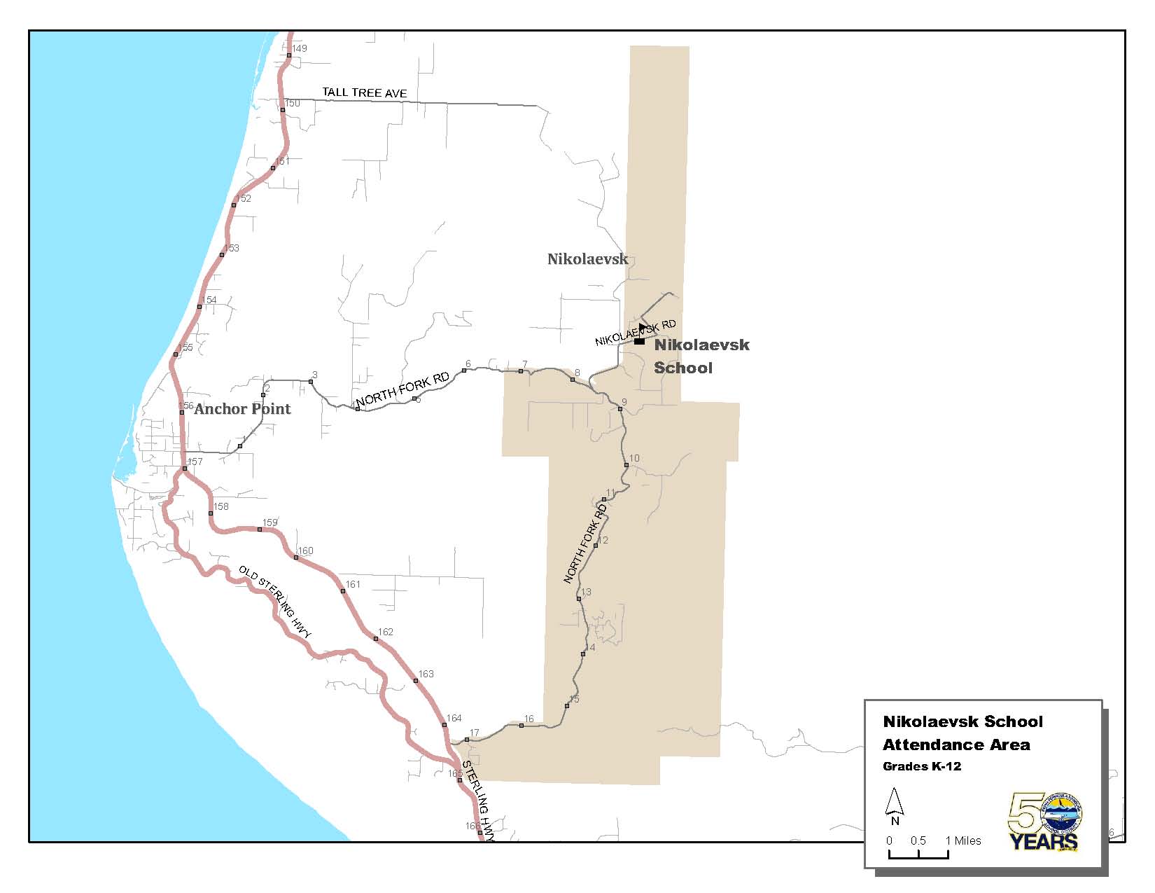
Nikolaevsk School (K-12)
For all grades along the North Fork Road from the south end to the Nikolaevsk turnoff. |
 |
 Click Map to Enlarge (pdf) |
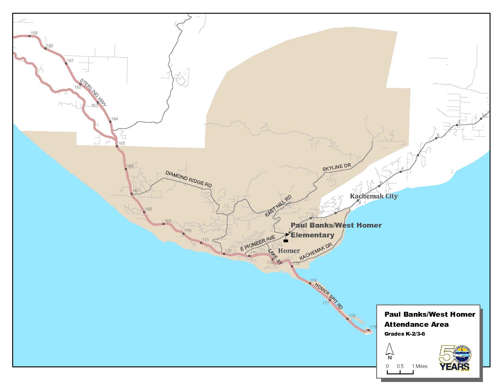
Paul Banks Elementary (K-2) and West Homer Elementary (3-6)
From Mile 8 on the north into Homer and the East End Road to Spencer Drive at approximately Mile 2. Includes all of the Homer City and Skyline Drive areas. |
 |
 Click Map to Enlarge (pdf) |
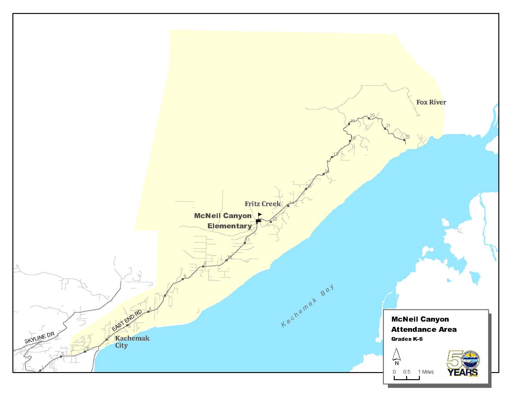
McNeil Canyon Elementary (K-6)
From Spencer Drive at approximately Mile 2 East End Road to Mile 22.5. |
 |
 Click Map to Enlarge (pdf) |
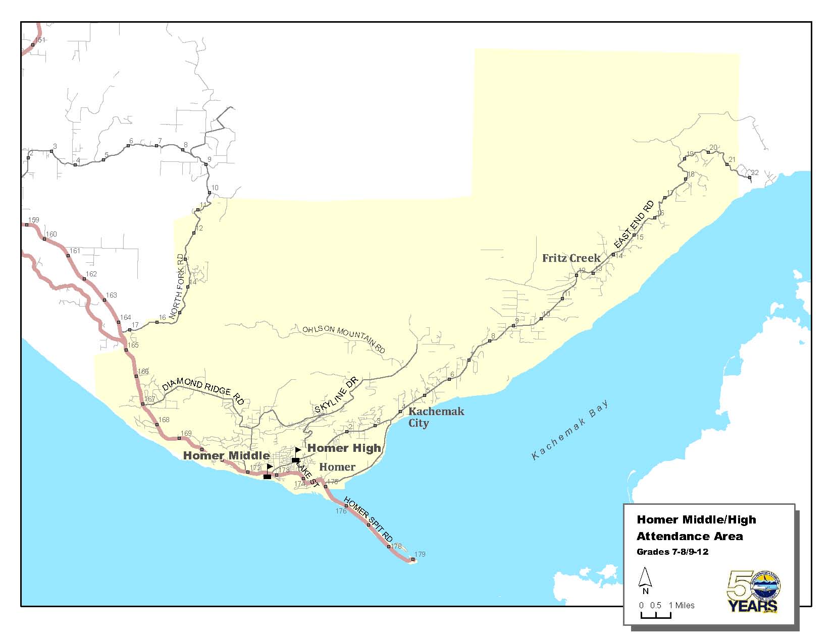
Homer High (9-12) and Homer Middle (7-8)
North Fork Road on the north into Homer and south to Mile 22.5 on the East End Road. Includes all of the area encompassed by McNeil Canyon Elementary, Paul Banks Elementary, and West Homer Elementary.
Because of bus schedules, Grade 7 and 8 students living on the south end of the North Fork Road have the choice of attending either Chapman School, or Homer Middle. Grade 9-12 students have the choice of attending Nikolaevsk School or Homer High. |
|